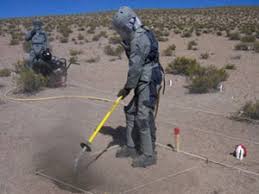
Soil management is a cornerstone of sustainable agriculture, urban planning, and environmental conservation. Traditional methods of soil analysis and management have often been invasive and labor-intensive, leading to potential damage to soil structure and ecosystems. However, innovative technologies like the air spade are transforming how we approach soil management. Coupled with aerial perspectives, these advancements offer a comprehensive view of soil health and facilitate more effective management practices.
Understanding the Airspade: A Revolutionary Tool
The Airspade is a pneumatic tool that uses compressed air to excavate soil. Unlike conventional digging tools, the Airspade dislodges soil particles gently and precisely without causing significant damage to roots, artifacts, or soil layers. This makes it an ideal instrument for various applications, from archaeological excavations to tree root inspections and soil research.
Integrating Aerial Perspectives
Drone Technology and Soil Analysis
The integration of drone technology with soil management practices has opened new avenues for efficient and comprehensive soil analysis. Drones equipped with advanced sensors and cameras can capture high-resolution images and data from above, providing a bird’s-eye view of the landscape. When combined with the detailed ground-level analysis enabled by the Airspade, this aerial perspective offers a holistic approach to soil management.
Benefits of Aerial Data
Aerial data collected by drones can identify areas of soil erosion, compaction, and other issues that may not be immediately apparent from the ground. These insights allow for targeted interventions, optimizing the use of resources and minimizing environmental impact. For instance, aerial imagery can highlight compacted areas where the Airspade can be employed to improve soil aeration and root health.
Applications of Airspade and Aerial Perspectives
Agriculture
In agriculture, managing soil health is crucial for maximizing crop yields and sustainability. Drones can survey large agricultural fields quickly, identifying areas that require attention. By pinpointing zones of poor soil health, farmers can use the Airspade to aerate compacted soil, enhance root growth, and improve water infiltration. This targeted approach ensures that interventions are precise and effective, leading to healthier crops and better yields.
Urban Forestry and Landscaping
Urban environments pose unique challenges for soil management due to limited space and high levels of soil compaction. Drones can map urban green spaces, providing valuable data on soil conditions and plant health. Arborists and landscapers can then use the Airspade to address specific problem areas, such as compacted soil around tree roots. This improves the overall health of urban greenery, contributing to a more sustainable and pleasant urban environment.
Environmental Conservation
For environmental scientists, understanding soil composition and health is vital for conservation efforts. Drones can monitor large conservation areas, identifying changes in soil health and vegetation cover over time. When problematic areas are identified, the Airspade can be used to perform non-invasive soil analysis and remediation, ensuring that conservation efforts are effective and minimally disruptive to the ecosystem.
Archaeology
Archaeologists benefit greatly from the combined use of aerial perspectives and the Airspade. Drones can survey archaeological sites, revealing features and structures that may not be visible from the ground. This information can guide precise excavation efforts using the Airspade, which protects delicate artifacts and stratigraphy. The result is a more accurate and efficient archaeological investigation, preserving historical context and integrity.
Advantages of Combining Airspade and Aerial Perspectives
Enhanced Precision and Efficiency
The synergy between aerial perspectives and the Airspade enhances both precision and efficiency in soil management. Drones provide a macro view, identifying areas of interest or concern, while the Airspade allows for detailed, non-invasive intervention at the micro level. This combination ensures that efforts are focused and effective, reducing unnecessary labor and environmental impact.
Comprehensive Data Collection
Aerial imagery and data collection complement the detailed ground-level analysis conducted with the Airspade. This comprehensive data set provides a deeper understanding of soil health and landscape dynamics, informing better decision-making and management practices.
Sustainable Practices
Integrating these technologies promotes sustainable soil management practices. By minimizing disruption and focusing interventions, we can preserve soil health and structure, supporting long-term environmental sustainability and productivity.
Conclusion
The combination of aerial perspectives and the Airspade is revolutionizing soil management. Drones provide valuable insights from above, identifying areas that require attention, while the Airspade offers precise, non-invasive solutions from below. This integrated approach enhances our ability to manage soil health effectively, promoting sustainability in agriculture, urban forestry, environmental conservation, and archaeology. By leveraging these innovative tools, we can unlock the full potential of our soil resources, ensuring a healthier and more productive future.


